By Kerry Lyman
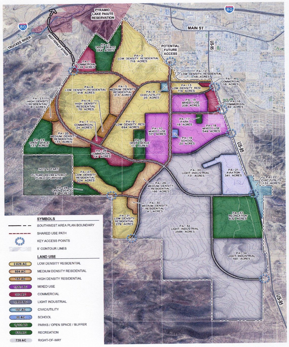
The Fernley City Council amended the city’s master plan for the second time this year by adopting another area plan last Wednesday, this time the 11,800-acre Southwest Area Plan (SW Area Plan), generally located south of the Truckee Canal and west of U.S. 95A
The 5,400-acre North Area Plan, located north of the I-80 freeway, was adopted in January. The SW Area Plan adoption was delayed twice, once in April due to the objections of a property owner controlling about 20 percent of the land area whose land had been designated as open space, which would have prevented any future development.
Another delay occurred earlier this month when it was learned that some of the required notices to affected property owners only contained empty envelopes.
Changes made to the area plan’s land use designations satisfied the large property owner who had objected to the plan in April, which caused the planning commission to recommend approval of the amended plan last month by a super majority 6-1 vote. In addition, proper notices were mailed to affected property owners, allowing council to approve the plan in a 3-0 vote, with Council members Felicity Zoberski and Joe Mendoza absent.
As with the North Area Plan, the SW Area Plan was adopted “due to the development pressure coming from the property owners. Several large developments are currently proposed within the area, and more are expected,” according to a city narrative summarizing the plan.
The area plan, working in conjunction with the city’s master plan and development code, is intended to establish a vision and objectives to transform the southwest area into a large master planned community “with vast employment opportunities, supporting commercial uses and a diverse range of housing types,” according to the narrative.
In a kind of checkerboard pattern, approximately 60 percent of the SW Area Plan is currently under private ownership, with about 40 percent owned by the Bureau of Land Management, which is expected to be conveyed to the city as part of phase I or phase II of the “Lands Bill” approved by Congress in late 2014.
LAND USES
Land uses within the SW Area Plan have been designated as follows:
- Excluding existing residential uses, 3,387 acres in the northern portion of the SW Area Plan are dedicated to residential uses
- 393 acres devoted to commercial uses
- 1,067 acres for mixed use, including multi-family apartments, condominiums and townhomes, live/work units, commercial retail, office, and neighborhood commercial.
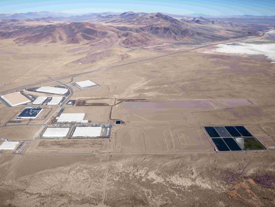
- 3,908 acres to light industrial uses, including light manufacturing, distribution, data centers, logistics, warehousing, major office and business uses, flex office, research centers, corporate headquarters, clean tech and medical uses
- 1,843 acres devoted to open space, including parks, recreational trails, hiking and biking trails, stormwater retention, and natural resource conservation
- 177 acres for public facilities, including 20 acres for a school and 157 acres for uses such as a library, civic center, emergency services and utilities infrastructure; and
- 341 acres for aviation related uses
It is anticipated the SW Area Plan could provide up to 28,318 housing units upon full buildout. The majority of the residential uses, 2,626 acres, anticipating up to 15,756 housing units, are devoted to low density residential (1 to 6 units per acre), while 604 acres and up to 7,852 housing units are intended for medium density residential (7 to 13 units per acre) and 157 acres and up to 4,710 units are dedicated toward high density residential (14 to 30 units per acre).
Commercial uses along major roadways in the SW Area Plan are intended for in-line and big box retail connected to adjacent land uses to try and reduce traffic in other areas of Fernley. Mixed uses, mainly along U.S. 95A, are intended to create a “town center” atmosphere in the area while providing easy access for other city residents, according to the city narrative.
The largest land area, at 3,908 acres, is devoted to light industrial uses and is located along the southern boundary of the SW Area Plan to limit truck traffic through residential areas, the narrative indicated.
The largest open space land area along the west of the area plan was chosen because slopes in this area prevent any significant development and residents in that area had expressed a strong desire in keeping nearby mountains as a scenic amenity during the earlier planning process, according to the narrative.
In addition, a large land parcel adjacent to the western open space area in the area plan, but not part of the SW Area Plan, is expected to be conveyed to the city as part of the “Lands Bill.” This will allow the city to connect the open space areas, creating a large regional park, the narrative indicated.
Also, 632 acres along U.S. 95A was preserved as open space due to an existing off-road racing track in this area, and 341 acres just north of the existing racing track and adjacent to U.S. 95A was dedicated to aviation due to the existing Samsarg airfield.
It is anticipated the airfield will support nearby industrial uses and could support aerospace-related land uses for offices and commercial. However, due to limited space for future expansion, it may make sense at some future date to relocate the airstrip farther south, according to the narrative.
WATER CAPACITY
As was the case with the North Area Plan, the most frequently asked question from both the public and elected officials was whether there is enough water to support expected development in the SW Area Plan. According to a water capacity study conducted by Kimley Horn, the consultant that prepared the SW Area Plan and manned all the public meetings, there is some water capacity available from groundwater wells only. Attempts by the city to obtain surface water rights may increase that capacity, it said.
The study noted that additional water needed to support development in the SW Area Plan depends on the future development demands. No upgrades will be necessary to the city’s water treatment plant or pump station, it said.
However, a new water transmission line, distribution pipes and additional water storage will be necessary. In addition, since current water storage tanks can serve up to elevations of 4,235 feet, and the majority of the southwest area lies above 4,235 feet in elevation, a new pressure zone, including additional booster pumps and storage tanks will be needed to maintain adequate water pressure, according to the study.
FISCAL IMPACT ANALYSIS
At full buildout, the SW Area Plan is expected to generate $122 million a year in property tax revenue, of which, the city would receive $23 million a year. “That is almost three times more than current property tax revenue,” according to the city staff narrative.
IMPLEMENTATION PLAN
The SW Area Plan divides projects and initiatives needed to be undertaken to implement the plan into categories such as high priority (1-3 years), moderate priority (4-7 years) and low priority (8+ years) as follows:
- High Priority
Complete surface water study
Adoption of an infrastructure plan
Zoning code update
NDOT coordination
BLM/BOR coordination
Master plan update
Capital improvement plan update
Stormwater runoff study
Airport master plan
City staffing study
- Moderate Priority
Update Transportation master plan
Safe routes to school plan update
Water infrastructure upgrades
Water conservation plan update
- Low Priority
Active transportation plan
Parks and trails plan



Comment
Comments